|
Hamatonbetsu, Hokkaido
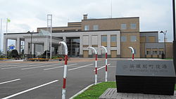
  Hamatonbetsu (浜頓別町, Hamatonbetsu-chō) is a town located in Sōya Subprefecture, Hokkaido, Japan.[1] As of 1 July 2024[update], the town had an estimated population of 3,263 in 1841 households, and a population density of 8.1 people per km2.[2] The total area of the town is 401.59 km2 (155.05 sq mi). GeographyHamatonbetsu is located in northeast Hokkaido; it faces the Sea of Okhotsk to the east where, during the winter, there is drift ice. Coastal areas of the town are marshy, and mountains spread out in the western and southern parts of the town. Lake Kutcharo designated a Ramsar site in July 1989, and host nearly 300 bird species either year round or as part of the avians' migratory pattern.[3] Parts of the town are within the borders of the North Okhotsk Prefectural Natural Park.[4]
Neighbouring municipalitiesClimateHamatonbetsu has cold and temperate climate considered to be Dfb according to the Köppen-Geiger climate classification. There is a considerable amount of rainfall even during months that typically experience dry weather. The average annual temperature in Hamatonbetsu is 5.9 °C. Each year, there is an approximate 1112 mm of precipitation. The temperatures are highest on average in August, at around 19.1 °C, and lowest in January, at around -6.6 °C.[5]
DemographicsPer Japanese census data, the population of Hamatonbetsu is as shown below. The town is in a long period of sustained population loss.[8]
HistoryThe name of "Tonbetsu" derives from the Ainu language word to-un-pet, which translates "river entering lake", and which referred to the Tonbetsu River which enters Lake Kutcharo. In 1878, the villages of Esashi, Tonbetsu, Utanobetsu, and Rebun were established in Esashi District, Kitami Province. In 1909 the four villages merged to form the village of Esashi; however, Tonbetsu was separated out in April 1916. In April 1921, Tonbestu was divided into Tonbetsu and Nakatonbetsu villages. Tonbetsu was raised to town status on November 1, 1951 and was renamed Hamatonbetsu due to its coastal location. GovernmentHamatonbetsu has a mayor-council form of government with a directly elected mayor and a unicameral town council of ten members. Hamatonbetsu, as part of Soya sub-prefecture, contributes one member to the Hokkaido Prefectural Assembly. In terms of national politics, the town is part of the Hokkaido 12th district of the lower house of the Diet of Japan. EconomyThe local economy of Hamatonbetsu is centered on commercial fishing and dairy farming. In particular, Hamatonbetsu is noted for its scallops, salmon and crabs. EducationHamatonbetsu has four public elementary schools and one public junior high school operated by the town government. The town has one public high school operated by the Hokkaido Board of Education. TransportationRailwaysHamatonbetsu has not had any passenger railway services since the closing of the JR Hokkaido Tempoku Line in 1989. The nearest railway station is Minami-Wakkanai Station or Otoineppu Station on the Sōya Main Line, a 1.5 hour bus ride away. HighwaysLocal attractions
Notable people from Hamatonbetsu
Mascot Hamatonbetsu's mascot is Swatton (スワットン) who is a gentle yet clumsy pig dressed as a tundra swan. He lives in areas surrounding Lake Kutcharo. His birthday is August 21. According to Ainu legend, he first appeared during the Jomon period to bring food and medical needs for good health and protection from crimes and natural disasters. Nowadays, he is no longer a god anymore. Instead, he is now a ballet dancer (who is auditioning for Swan Lake) and the assistant to the mayor. He still helps the town to children and adults around the world and brings happiness during difficult times by his dance moves while promoting the town. He knows laughter is the best medicine.[9] References
External links
|
||||||||||||||||||||||||||||||||||||||||||||||||||||||||||||||||||||||||||||||||||||||||||||||||||||||||||||||||||||||||||||||||||||||||||||||||||||||||||||||||||||||||||||||||||||||||||||||||||||||||||||||||||||||||||||||||||||||||||||||||||||||||||||


