County in Guangdong, People's Republic of China
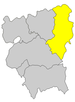
Longchuan County (postal: Lungchun; simplified Chinese: 龙川县; traditional Chinese: 龍川縣; pinyin: Lóngchuān Xiàn; lit. 'dragon river county', Hakka: Liùngchôn) is a county of northeastern Guangdong province, China, bordering Jiangxi to the north and on the upper reaches of the Dong and Han Rivers. It is under the administration of Heyuan City, and in 2020 had a population of 595,471[1] living in an area of 3,088 km2 (1,192 sq mi). Bordering county-level divisions are Xingning and Wuhua County to the east, Heping County and Dongyuan County to the south and west, and in Jiangxi, Dingnan County and Xunwu County to the north.
Administrative divisions
 Map of Longchuan (labeled as LUNG-CH'UAN 龍川 (LUNGCHUN)) and surrounding region (AMS, 1954)
Longchuan administers 24 towns:
Transport
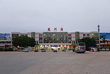
 Longchuan railway station
Longchuan has a developed highway and railway network. Major roads include the China National Highway 205 (G205) and Guangdong Provincial Highway 120 (S120). The Beijing–Kowloon, Guangzhou–Meizhou–Shantou and Zhangping–Longchuan Railways intersect in Longchuan, making it an important railway hub for the Lingnan region.
Sights
Climate
| Climate data for Longchuan (1991–2020 normals, extremes 1981–2010)
|
| Month
|
Jan
|
Feb
|
Mar
|
Apr
|
May
|
Jun
|
Jul
|
Aug
|
Sep
|
Oct
|
Nov
|
Dec
|
Year
|
| Record high °C (°F)
|
28.3
(82.9)
|
30.2
(86.4)
|
32.9
(91.2)
|
35.0
(95.0)
|
36.8
(98.2)
|
38.7
(101.7)
|
39.1
(102.4)
|
39.5
(103.1)
|
37.4
(99.3)
|
36.1
(97.0)
|
34.5
(94.1)
|
29.9
(85.8)
|
39.5
(103.1)
|
| Mean daily maximum °C (°F)
|
17.1
(62.8)
|
19.1
(66.4)
|
21.9
(71.4)
|
26.3
(79.3)
|
29.9
(85.8)
|
32.0
(89.6)
|
33.9
(93.0)
|
33.5
(92.3)
|
31.7
(89.1)
|
28.5
(83.3)
|
24.1
(75.4)
|
18.8
(65.8)
|
26.4
(79.5)
|
| Daily mean °C (°F)
|
11.6
(52.9)
|
13.8
(56.8)
|
16.9
(62.4)
|
21.5
(70.7)
|
25.0
(77.0)
|
27.2
(81.0)
|
28.5
(83.3)
|
28.0
(82.4)
|
26.5
(79.7)
|
23.0
(73.4)
|
18.3
(64.9)
|
13.2
(55.8)
|
21.1
(70.0)
|
| Mean daily minimum °C (°F)
|
8.1
(46.6)
|
10.3
(50.5)
|
13.5
(56.3)
|
18.1
(64.6)
|
21.7
(71.1)
|
24.0
(75.2)
|
24.8
(76.6)
|
24.6
(76.3)
|
23.0
(73.4)
|
19.2
(66.6)
|
14.4
(57.9)
|
9.5
(49.1)
|
17.6
(63.7)
|
| Record low °C (°F)
|
−1.0
(30.2)
|
0.4
(32.7)
|
0.7
(33.3)
|
6.6
(43.9)
|
12.7
(54.9)
|
17.6
(63.7)
|
18.7
(65.7)
|
20.2
(68.4)
|
15.6
(60.1)
|
8.2
(46.8)
|
2.9
(37.2)
|
−2.5
(27.5)
|
−2.5
(27.5)
|
| Average precipitation mm (inches)
|
59.1
(2.33)
|
77.7
(3.06)
|
154.1
(6.07)
|
195.2
(7.69)
|
235.1
(9.26)
|
278.9
(10.98)
|
173.9
(6.85)
|
210.9
(8.30)
|
127.9
(5.04)
|
44.8
(1.76)
|
47.1
(1.85)
|
47.7
(1.88)
|
1,652.4
(65.07)
|
| Average precipitation days (≥ 0.1 mm)
|
7.7
|
10.4
|
15.6
|
15.5
|
17.8
|
18.7
|
16.2
|
17.4
|
11.1
|
4.9
|
6.0
|
6.3
|
147.6
|
| Average relative humidity (%)
|
74
|
77
|
80
|
80
|
80
|
81
|
78
|
79
|
77
|
70
|
71
|
70
|
76
|
| Mean monthly sunshine hours
|
116.6
|
96.6
|
87.0
|
98.5
|
130.4
|
149.9
|
208.8
|
190.1
|
175.7
|
181.5
|
157.6
|
142.5
|
1,735.2
|
| Percent possible sunshine
|
35
|
30
|
23
|
26
|
32
|
37
|
50
|
48
|
48
|
51
|
48
|
43
|
39
|
| Source: China Meteorological Administration[2][3]
|
See also
References


