|
Nuup Kangerlua
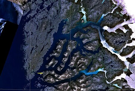
Nuup Kangerlua[1] is a 160 km (99.4 mi) long fjord[2] in the Sermersooq municipality in southwestern Greenland. It was formerly known by its colonial name as Godthaab Fjord (Danish: Godthåbsfjorden), Gilbert Sound[3] and Baal's River.[4] Located by the island's capital, Nuuk, it is the longest fjord on the Labrador Sea coast of Greenland, and one of the longest in the inhabited part of the country.[2] GeographyThe fjord head is located deep inland, with the fjord beginning as an icefjord at 64°19′50″N 49°36′10″W / 64.33056°N 49.60278°W, with two glaciers draining the Greenland ice sheet (Greenlandic: Sermersuaq) flowing into the fjord. Initially, the fjord flows to the northwest, to then turn southwest at 64°43′N 50°37′W / 64.717°N 50.617°W, splitting into three arms in its lower run, with three large, mountainous islands in between the arms: Sermitsiaq Island with the Sermitsiaq mountain visible from most of Nuuk, Qeqertarsuaq Island, and Qoornuup Qeqertarsua Island.[5] The fjord widens into a bay dotted with skerries near its mouth, opening into Labrador Sea at approximately 64°03′N 51°58′W / 64.050°N 51.967°W, near the former Kangeq settlement.
SettlementNuuk, the capital of Greenland, is located near the mouth of the fjord, on a mountainous peninsula bounding the fjord from the southeast. Kapisillit is located 75 km (47 mi) northeast of Nuuk, near the head of Kapisillit Kangerluaq,[5] one of the tributary fjords of Nuup Kangerlua. See alsoReferencesWikimedia Commons has media related to Nuup Kangerlua.
|
|||||||||||||||||||||


