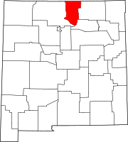
Census-designated place in New Mexico, United States
San Cristobal is a census-designated place in Taos County , New Mexico . Its population was 273 as of the 2010 census ,[ 4] 2020 census the population was 206 persons with a total number of households at 49.[ 5] post office with ZIP code 87564, which opened on February 16, 1932.[ 6] [ 7]
Geography
According to the U.S. Census Bureau , the community has an area of 6.886 square miles (17.83 km2 ), all land.[ 8]
Demographics
In San Cristobal, New Mexico, the top 5 ethnic groups by percentage are White (Hispanic), White (Non-Hispanic), Other (Hispanic), American Indian & Alaska Native (Non-Hispanic), and Black or African American (Non-Hispanic).[ 9]
Historical population
Census Pop. Note %± 2020 206 —
Education
It is within Taos Municipal Schools ,[ 11] Taos High School .
References
^ "ArcGIS REST Services Directory" . United States Census Bureau. Retrieved October 12, 2022 .^ a b U.S. Geological Survey Geographic Names Information System: San Cristobal, New Mexico ^ a b "Census Population API" . United States Census Bureau. Retrieved October 12, 2022 .^ "U.S. Census website" . United States Census Bureau . Retrieved May 14, 2011 .^ "San Cristobal, New Mexico" . United States Census Bureau . Retrieved November 16, 2024 .^ "Postmaster Finder - Post Offices by ZIP Code" . United States Postal Service . Retrieved July 11, 2014 .^ United States Postal Service (2012). "USPS - Look Up a ZIP Code" . Retrieved February 15, 2012 . ^ "2010 Census Gazetteer Files: Places: New Mexico" . U.S. Census Bureau . Archived from the original on July 14, 2014. Retrieved July 11, 2014 .^ "San Cristobal, NM | Data USA" . datausa.io . Retrieved February 13, 2023 .^ "Census of Population and Housing" . Census.gov. Retrieved June 4, 2016 .^ "2020 CENSUS - SCHOOL DISTRICT REFERENCE MAP: Taos County, NM" (PDF) . U.S. Census Bureau . Retrieved July 12, 2022 .


