Share to:


Te Kūiti

Te Kūiti
Te Kūiti viewed from the south-west as SH3 climbs out of the town.
Map
Coordinates: 38°20′S 175°10′E / 38.333°S 175.167°E / -38.333; 175.167
CountryNew Zealand
RegionWaikato region
DistrictWaitomo District
WardTe Kuiti Ward
Electorates
Government
 • Territorial AuthorityWaitomo District Council
 • Regional councilWaikato Regional Council
Area
 • Total
8.41 km2 (3.25 sq mi)
Population
 (June 2024)[2]
 • Total
4,890
 • Density580/km2 (1,500/sq mi)
Postcode(s)
3910

Te Kūiti is a town in the north of the King Country region of the North Island of New Zealand. It lies at the junction of State Highways 3 and 30 and on the North Island Main Trunk railway, 80 kilometres (50 mi) south of Hamilton. The town promotes itself as the sheep shearing capital of the world and is host to the annual New Zealand National Shearing Championships.

Te Kūiti is approximately 80 km south of Hamilton and 19 km south-east of Waitomo. The area around Te Kūiti, commonly known as the King Country, gives its name to the Heartland Championship rugby team based in Te Kūiti.

History and culture
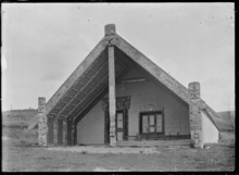
Te Tokanganui-a-Noho meeting house in Te Kūiti, 1917

Te Kūiti is the Māori name given to the area. In its original form of "Te Kūititanga", it literally means "the valley", "the squeezing in" or "the narrowing".[3]

Several marae are located in and around Te Kūiti, associated with Ngāti Maniapoto hapū:[4][5]

  • Te Kumi Marae and Te Korapatu meeting house are affiliated with Ngāti Peehi and Rōrā
  • Mōtītī Marae and Ko te Hungaiti or Hapainga meeting house are affiliated with Ngāti Kinohaku, Ngāti Putaitemuri and Ngāti Tauhunu
  • Te Piruru Papakainga Marae and Te Pukenui o Taonui meeting house are affiliated with Ngāti Rōrā
  • Tāne Hopuwai Marae and Tāne Hopuwai meeting house are affiliated with Ngāti Apakura
  • Te Tokanganui a Noho Marae and meeting house are affiliated with Ngāti Rōrā. This wharenui was constructed in 1873 for Te Kooti and his followers, and was one of the largest wharenui ever built at the time.[6]
  • Tomotuki Marae and Parekatini meeting house are affiliated with Apakura, Parekaitini and Ngāti Rōrā
  • Te Waipatoto Marae, and Waipatoto and Waipatoto Tuarua meeting houses, are affiliated with Ngāti Kinohaku

Geography

Limestone deposits and water have created the Waitomo Caves, northwest of the town, one of New Zealand's most-visited tourist locations. The town itself is located in a valley with many rich limestone deposits.[7] The Manga-o-Kewa Stream runs through the valley and is a tributary of the Waipā River.[8] Te Kūiti's hinterland consist mainly of farmland and limestone quarries. The land surrounding Te Kūiti has steep hilly relief which reflects the nature of the North King Country region. The climate of Te Kūiti is wet during the winter and dry during the late summer with an average of 1,450mm of rainfall each year.[9]

Climate

Climate data for Te Kuiti (1991–2020)
Month Jan Feb Mar Apr May Jun Jul Aug Sep Oct Nov Dec Year
Mean daily maximum °C (°F) 24.4
(75.9)
24.9
(76.8)
23.3
(73.9)
20.1
(68.2)
16.9
(62.4)
14.3
(57.7)
13.6
(56.5)
14.7
(58.5)
16.5
(61.7)
18.0
(64.4)
20.1
(68.2)
22.4
(72.3)
19.1
(66.4)
Daily mean °C (°F) 18.3
(64.9)
18.9
(66.0)
17.0
(62.6)
14.3
(57.7)
11.6
(52.9)
9.4
(48.9)
8.6
(47.5)
9.6
(49.3)
11.4
(52.5)
13.0
(55.4)
14.5
(58.1)
17.0
(62.6)
13.6
(56.5)
Mean daily minimum °C (°F) 12.3
(54.1)
12.8
(55.0)
10.7
(51.3)
8.5
(47.3)
6.3
(43.3)
4.4
(39.9)
3.6
(38.5)
4.5
(40.1)
6.4
(43.5)
8.0
(46.4)
9.0
(48.2)
11.5
(52.7)
8.2
(46.7)
Average rainfall mm (inches) 83.8
(3.30)
82.7
(3.26)
75.8
(2.98)
107.9
(4.25)
140.9
(5.55)
144.1
(5.67)
174.1
(6.85)
138.8
(5.46)
137.5
(5.41)
133.6
(5.26)
115.0
(4.53)
129.3
(5.09)
1,463.5
(57.61)
Mean monthly sunshine hours 221.6 180.7 191.4 147.5 120.6 102.5 109.6 127.8 134.2 164.6 184.8 185.8 1,871.1
Source: NIWA[10]

Demographics

Te Kūiti covers 8.41 km2 (3.25 sq mi)[1] and had an estimated population of 4,890 as of June 2024,[2] with a population density of 581.5 people per km2.

Historical population
YearPop.±% p.a.
20014,374—    
20064,494+0.54%
20134,257−0.77%
20184,572+1.44%
Source: [11]

Te Kūiti had a population of 4,572 at the 2018 New Zealand census, an increase of 315 people (7.4%) since the 2013 census, and an increase of 78 people (1.7%) since the 2006 census. There were 1,611 households, comprising 2,241 males and 2,331 females, giving a sex ratio of 0.96 males per female, with 1,041 people (22.8%) aged under 15 years, 894 (19.6%) aged 15 to 29, 1,872 (40.9%) aged 30 to 64, and 768 (16.8%) aged 65 or older.

Ethnicities were 51.7% European/Pākehā, 55.2% Māori, 5.6% Pacific peoples, 5.7% Asian, and 1.3% other ethnicities. People may identify with more than one ethnicity.

The percentage of people born overseas was 11.4, compared with 27.1% nationally.

Although some people chose not to answer the census's question about religious affiliation, 50.2% had no religion, 32.7% were Christian, 4.4% had Māori religious beliefs, 1.1% were Hindu, 1.0% were Muslim, 0.5% were Buddhist and 1.4% had other religions.

Of those at least 15 years old, 318 (9.0%) people had a bachelor's or higher degree, and 1,047 (29.7%) people had no formal qualifications. 222 people (6.3%) earned over $70,000 compared to 17.2% nationally. The employment status of those at least 15 was that 1,566 (44.4%) people were employed full-time, 561 (15.9%) were part-time, and 195 (5.5%) were unemployed.[11]

Individual statistical areas
Name Area
(km2)
Population Density
(per km2)
Households Median age Median
income
Te Kūiti West 2.59 2,598 1,003 918 38.2 years $24,500[12]
Te Kūiti East 5.83 1,974 339 693 35.1 years $23,500[13]
New Zealand 37.4 years $31,800

Tourism

Te Kūiti railway station

The "Shearing Capital of the World" contains the world's largest shearer, seven metres high. On 1 April 2006 the largest sheep show in the world took place here, with more than 2000 sheep.[14]

Statue celebrating the shearing industry in Te Kūiti

The carved Te Tokanganui-a-Noho meeting house was gifted to the local Maori people (Ngāti Maniapoto) by Te Kooti, the most famous Maori rebel leader of the 19th century. He was given sanctuary by the chiefs of Maniapoto against the white colonial Government of New Zealand and under Maniapoto's protection carved one of the most famous and important late 19th century spiritual houses in the North Island. This house is central to Te Kūiti's historical foundation, also referred to as the epicentre of the Rohe Pōtae or "King Country". In 1881 the last frontier was opened to colonial settlers.

The Tatsuno Japanese Garden is at the southern end of the main street.[15]

The Mangaokewa reserve located 5 km south of Te Kūiti is a popular attraction for rock climbers, hikers, picnic goers, swimmers and trout fisherman in the region.[16]

A 'Revitalisation Project' for the NZHPT Category II listed[17] Te Kuiti railway station was started in 2014[18] to provide for arts and crafts groups, an education centre, youth projects, historical displays and a meeting room.[19] The Rail Heritage Trust describes the station as, "the finest remaining example of a standard class B station".[20]

Sport

Sign for Waitete Rugby Club, the home of Colin and Stan Meads.

Te Kūiti is the home of the Waitete Rugby Football Club and the King Country Rugby Union, both of whom are based at Rugby Park. The famous Colin Meads spent the entirety of his career with both Waitete and King Country. The town also has an association football club, Te Kuiti Albion Football Club, who play in the Deacon Shield tournament. They play their home games at Centennial Park where there is a small clubroom. The club colours are yellow and black striped shirts and black shorts.

Education

Te Kūiti has six schools:

  • Te Kūiti Primary School is a state primary school,[21] with a roll of 352.[22]
  • Pukenui School is a state primary school,[23] with a roll of 148.[24]
  • Centennial Park School is a state primary school,[25] with a roll of 60.[26]
  • St Joseph's Catholic School is a Catholic state integrated primary school,[27] with a roll of 69.[28]
  • Te Kūiti High School is a state secondary school,[29][30] with a roll of 285.[31]
  • Te Wharekura o Maniapoto is a state Māori immersion school,[32] with a roll of 131.[33]

All these schools are co-educational. Rolls are as of August 2024.[34]

Notable people

References

  1. ^ a b "ArcGIS Web Application". statsnz.maps.arcgis.com. Retrieved 8 November 2022.
  2. ^ a b "Aotearoa Data Explorer". Statistics New Zealand. Retrieved 26 October 2024.
  3. ^ Te Kūiti in An Encyclopaedia of New Zealand (1966)
  4. ^ "Te Kāhui Māngai directory". tkm.govt.nz. Te Puni Kōkiri.
  5. ^ "Māori Maps". maorimaps.com. Te Potiki National Trust.
  6. ^ Walker, Ranginui (2004). Ka Whawhai Tonu Matou - Struggle Without End (2nd ed.). Auckland, New Zealand: Penguin Books. p. 189. ISBN 9780143019459.
  7. ^ Taonga, New Zealand Ministry for Culture and Heritage Te Manatu. "4. – Rock, limestone and clay – Te Ara Encyclopedia of New Zealand". www.teara.govt.nz.
  8. ^ "Mangaokewa Stream fishing-Mangaokewa Stream trout fishing-nzfishingv". www.nzfishing.com.
  9. ^ Environment Waikato Archived 14 October 2008 at the Wayback Machine
  10. ^ "CliFlo – National Climate Database : Te Kuiti Ews". NIWA. Retrieved 20 May 2024.
  11. ^ a b "Statistical area 1 dataset for 2018 Census". Statistics New Zealand. March 2020. Te Kuiti West (187300) and Te Kuiti East (187400).
  12. ^ 2018 Census place summary: Te Kuiti West
  13. ^ 2018 Census place summary: Te Kuiti East
  14. ^ Television NZ News. 1 April 2006
  15. ^ "Things to see and do in Te Kuiti, New Zealand". www.newzealand.com.
  16. ^ "Waitomo - parks". Archived from the original on 2 June 2010.
  17. ^ "Search the List - Te Kuiti Railway Station - Heritage New Zealand". www.heritage.org.nz.
  18. ^ "Railway Station Buildings Revitalisation Project - Waitomo District Council". www.waitomo.govt.nz.
  19. ^ "Waitomo News 23 August 2012" (PDF).
  20. ^ "Rail Heritage Trust of New Zealand - Te Kuiti Station". www.railheritage.org.nz.
  21. ^ "Te Kuiti Primary School Ministry of Education School Profile". educationcounts.govt.nz. Ministry of Education.
  22. ^ "Te Kuiti Primary School Education Review Office Report". ero.govt.nz. Education Review Office.
  23. ^ "Pukenui School Ministry of Education School Profile". educationcounts.govt.nz. Ministry of Education.
  24. ^ "Pukenui School Education Review Office Report". ero.govt.nz. Education Review Office.
  25. ^ "Centennial Park School Ministry of Education School Profile". educationcounts.govt.nz. Ministry of Education.
  26. ^ "Centennial Park School Education Review Office Report". ero.govt.nz. Education Review Office.
  27. ^ "St Joseph's Catholic School Ministry of Education School Profile". educationcounts.govt.nz. Ministry of Education.
  28. ^ "St Joseph's Catholic School Education Review Office Report". ero.govt.nz. Education Review Office.
  29. ^ "Te Kuiti High School Official School Website". tkhs.school.nz.
  30. ^ "Te Kuiti High School Ministry of Education School Profile". educationcounts.govt.nz. Ministry of Education.
  31. ^ "Te Kuiti High School Education Review Office Report". ero.govt.nz. Education Review Office.
  32. ^ "Te Wharekura o Maniapoto Ministry of Education School Profile". educationcounts.govt.nz. Ministry of Education.
  33. ^ "Te Wharekura o Maniapoto Education Review Office Report". ero.govt.nz. Education Review Office.
  34. ^ "New Zealand Schools Directory". New Zealand Ministry of Education. Retrieved 17 September 2024.
  35. ^ Bassett, Michael. "Profile". Archived from the original on 9 March 2012. Retrieved 31 January 2008.
  36. ^ kevin Boroevich at the All Blacks (archived)
  37. ^ Gustafson, Barry (1986). The First 50 Years : A History of the New Zealand National Party. Auckland: Reed Methuen. p. 301. ISBN 0-474-00177-6.
  38. ^ Noted. "New Zealand Listener - Noted". Noted.
  39. ^ "Copping a Bad Egg - theage.com.au". www.theage.com.au. 19 July 2003.
  40. ^ "Meads farm makes $1.4m at auction retrieved January 2008".
  41. ^ Hamilton, Tom (19 June 2017). "'Welcome to Meadsville' - New Zealand honours Sir Colin Meads". ESPN (UK). Retrieved 19 June 2017.
  42. ^ "All Blacks legend Colin Meads dies". ESPN (UK). Australian Associated Press. 19 August 2017. Retrieved 20 August 2017.
  43. ^ "Hawke's Bay Today". NZ Herald.
Kembali kehalaman sebelumnya