Share to:


Toplica District

Топлички округ
Toplički okrug
Images from the Toplica District
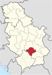
Location of the Toplica District within Serbia
Coordinates: 43°14′N 21°36′E / 43.233°N 21.600°E / 43.233; 21.600
Country Serbia
Administrative centerProkuplje
Government
 • CommissionerNebojša Vukadinović
Area
 • Total
2,231 km2 (861 sq mi)
Population
 (2022 census)[1]
 • Total
77,341
 • Density35/km2 (90/sq mi)
ISO 3166 codeRS-21
Municipalities4
Settlements267
- Cities and towns4
- Villages263

The Toplica District (Serbian: Топлички округ, Toplički okrug, pronounced [tǒplit͡ʃkiː ôkruːɡ]) is an administrative district in southern Serbia, named after the river Toplica. As of the 2022 census, the district has a population of 77,341 inhabitants,[1] making it the smallest district by population in Serbia. Its administrative center is the city of Prokuplje.

Municipalities

It encompasses the city of Prokuplje and three municipalities:

Demographics

Historical population
YearPop.±%
1948141,502—    
1953149,421+5.6%
1961141,141−5.5%
1971129,542−8.2%
1981121,933−5.9%
1991111,813−8.3%
2002102,075−8.7%
201191,754−10.1%
202277,900−15.1%
Source: [2][1]

As of the 2022 census, the district has a population of 77,900 inhabitants.[1]

Ethnic groups

Ethnic composition of the municipality:

Ethnic group Population %
Serbs 73,045 94.44%
Romani 3,734 4.82%
Macedonians 68 0.08%
Albanians 28 0.03%
Bulgarians 25 0.03%
Total 77,341 100%

See also

References

  1. ^ a b c d "Prvi rezultati Popisa stanovništva, domaćinstava i stanova 2022". stat.gov.rs (in Serbian). 21 December 2022. Retrieved 16 February 2023. d
  2. ^ "2011 Census of Population, Households and Dwellings in the Republic of Serbia" (PDF). stat.gov.rs. Statistical Office of the Republic of Serbia. Retrieved 12 January 2017.

Note: All official material made by the Government of Serbia is public by law. Information was taken from the official website.

Kembali kehalaman sebelumnya