|
York Street, Sydney
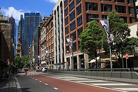
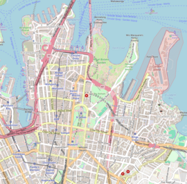
York Street is a street in the Sydney central business district in New South Wales, Australia. York Street runs 1.050 kilometres (0.652 mi)[1] in a north to south direction only. RouteFrom its northern terminus at the junction of Grosvenor Street with the Bradfield Highway, York Street runs south past Wynyard railway station, with major intersections at King and Market streets. The southern terminus of York Street is at Druitt Street, adjacent to the Sydney Town Hall and the Queen Victoria Building. Between Market Street and Druitt Street, traffic is restricted to buses, bicycles and service vehicles only. The City Circle and North Shore railway lines run under York Street. HistoryNamed in 1810 by Governor Lachlan Macquarie after the Prince Frederick, Duke of York and Albany, the second eldest child, and second son, of King George III, and brother of King William IV. It was originally known as Barracks Row as it began at the old Barracks parade ground. The southern end became home to many import and export companies, being attracted to the area by the markets established there in Macquarie's time. The northern end beyond Wynyard Square did not come into existence until 1848 when the land occupied by the Wynyard Barracks was resumed and subdivided. Half of this new section, along with Princes Street into which it ran, disappeared with the resumption of land for the Sydney Harbour Bridge approaches in The Rocks area.[2] On 21 July 1997, a bus lane was introduced along the full length of York Street.[3][4] Points of interest
References
External linksWikimedia Commons has media related to York Street, Sydney.
|
||||||||||||||||||||||||||||||||


