Jaén
| Jaén | |||||||||||
|---|---|---|---|---|---|---|---|---|---|---|---|
| Espainiako udalerria | |||||||||||
.jpg) | |||||||||||
| |||||||||||
| Administrazioa | |||||||||||
| Estatu burujabe | |||||||||||
| Autonomia | |||||||||||
| Probintzia | Jaéngo probintzia | ||||||||||
| Alkatea | Julio Millán Muñoz (en) | ||||||||||
| Izen ofiziala | Jaén | ||||||||||
| Posta kodea | 23001–23009 | ||||||||||
| INEk ezarritako kodea | 23050 | ||||||||||
| Herriburua | Jaén | ||||||||||
| Geografia | |||||||||||
| Koordenatuak | 37°46′11″N 3°47′20″W / 37.7697°N 3.7889°W | ||||||||||
 | |||||||||||
 | |||||||||||
| Azalera | 424,3 km² | ||||||||||
| Altitudea | 573 m | ||||||||||
| Mugakideak | La Guardia de Jaén, Pegalajar, Campillo de Arenas, Valdepeñas de Jaén, Los Villares, Torredelcampo, Fuerte del Rey, Cazalilla, Mengíbar, Villatorres, Mancha Real eta Begíjar | ||||||||||
| Demografia | |||||||||||
| Biztanleria | 112.235 (2025) | ||||||||||
| |||||||||||
| Dentsitatea | 265 bizt/km² | ||||||||||
| Informazio gehigarria | |||||||||||
| Sorrera | 825 | ||||||||||
| Telefono aurrizkia | 953 y 853 | ||||||||||
| Ordu eremua | UTC+01:00 eta UTC+02:00 | ||||||||||
| Hiri senidetuak | Arezzo | ||||||||||
| Matrikula | J | ||||||||||
| aytojaen.es | |||||||||||


Jaén[1] Espainiako hiria da, izen bereko probintziako hiriburua, Andaluziako autonomia erkidegoan kokatuta dagoena.
2008. urtean, 116.417 biztanle zituen.
Mugakideak
Jaének honako udalerri mugakideak ditu: Cazalilla ipar-mendebaldean, Mengíbar eta Villatorres iparraldean, Begíjar ipar-ekialdean, Mancha Real, La Guardia de Jaén eta Pegalajar ekialdean, Campillo de Arenas hego-ekialdean, Valdepeñas de Jaén hegoaldean, Los Villares hego-mendebaldean, eta Fuerte del Rey eta Torredelcampo mendebaldean.
Banaketa administratiboa
Auzoak
| Erdialdeko barrutia | San Ildefonso, La Victoria, Centro. |
| Alde Zaharra | La Magdalena, San Vicente de Paúl, La Merced, Sagrario, El Arrabalejo, San Bartolomé, San Juan, Judería. |
| Mendebaldeko barrutia | La Granja, Peñamefécit, Las Fuentezuelas, Santa Isabel, La Imora, Valdeastillas. |
| Ekialdeko barrutia | Egido de Belén, Loma del Royo, San Roque, El Almendral. |
| Iparraldeko barrutia | Expansión Norte, Marroquíes Bajos, Los Olivares, Vaciacostales. |
| Hegoaldeko barrutia | Tiro Nacional, El Tomillo, San Felipe, La Gloria, San Sebastián, Fuente de la Peña. |
| El Valle barrutia | El Valle, Las Lagunillas, Sagrada Familia. |
| La Alcantarilla barrutia | La Alcantarilla, San Félix, El Recinto, Valparaíso. |
| Los Puentes barrutia | Cerro Molina, Puente Tablas, Puente de la Sierra, Puente Nuevo, Puente Jontoya, Nuevo Mundo. |
Herriak
Hiriaren erdigunean biztanleriaren %95 bizi da, eta honen inguruan, herri txikiagoak daude:
- Caño Quebrado
- Brujuelo
- Grañera
- Las Infantas
- Jabalcuz
- Otiñar
- Puente Jontoya
- Puente Nuevo
- Puente de la Sierra
- Puente Tablas
- Puerto Alto
- Ventosilla
- Villar de Cuevas
Eraikinak
Jaengo Jasokundearen katedrala (gaztelaniaz Santa Iglesia Catedral de la Asunción de la Virgen)
Pizkunde garaiko arkitektura du. Gaur egungo eraikina XVI. mendean proiektatu zen, 1660. urtean sagaratu eta azkenik 1724ean amaitu zelarik.
Klima
| | |||||||||||||
|---|---|---|---|---|---|---|---|---|---|---|---|---|---|
| Hila | Urt | Ots | Mar | Api | Mai | Eka | Uzt | Abu | Ira | Urr | Aza | Abe | Urtekoa |
| Erregistraturiko tenperatura maximoa (°C) | 18.1 | 20.2 | 25.1 | 26.8 | 32.5 | 36.6 | 38.7 | 38.4 | 34.0 | 28.1 | 21.8 | 18.1 | 38.7 |
| Batez besteko tenperatura maximoa (°C) | 12.0 | 13.8 | 16.6 | 19.9 | 24.1 | 29.9 | 34.5 | 34.0 | 29.3 | 22.5 | 16.5 | 12.5 | 22.1 |
| Batez besteko tenperatura (ºC) | 8.4 | 10.0 | 13.0 | 14.6 | 19.1 | 25.4 | 27.6 | 27.2 | 23.8 | 17.7 | 11.7 | 9.3 | 17.3 |
| Batez besteko tenperatura minimoa (°C) | 4.7 | 5.6 | 7.3 | 9.5 | 12.8 | 16.9 | 20.5 | 20.5 | 17.6 | 12.8 | 8.3 | 5.2 | 11.8 |
| Erregistraturiko tenperatura minimoa (°C) | -0.5 | 2.5 | 2.6 | 4.6 | 8.0 | 13.0 | 15.4 | 15.8 | 12.9 | 8.6 | 3.0 | 0.02 | -0.5 |
| Pilatutako prezipitazioa (mm) | 75 | 80 | 83 | 61 | 49 | 20 | 4 | 5 | 28 | 54 | 57 | 76 | 593 |
| Prezipitazio egunak (≥ 1 mm) | 10 | 14 | 14 | 10 | 4 | 3 | 3 | 1 | 5 | 9 | 7 | 6 | 86 |
| Hezetasuna (%) | 60.8 | 57.1 | 52.5 | 52.8 | 52.5 | 43.9 | 42.4 | 44.6 | 52.0 | 58.2 | 62.2 | 64.3 | 53.6 |
| Iturria: Agencia Estatal de Meteorología | |||||||||||||
Demografia

Argazkiak
-
 Torralbako kondearen dorrea
 -
 Andaluziako etorbidea
 -
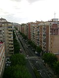
 Hiriko iparraldeko auzoak
 -
 Jaéngo udaletxea
 -
 Jaéngo diputazioaren egoitza


Jaendar ezagunak
- Francisco Coello (1822-1898), militar eta kartografoa.
Ikus, gainera
Erreferentziak
Kanpo estekak
- (Gaztelaniaz) Jaengo Udala

Content Disclaimer
Informasi ini disarikan dari Wikipedia dan disajikan kembali untuk tujuan edukasi. Konten tersedia di bawah lisensi CC BY-SA 3.0. Kami tidak bertanggung jawab atas ketidakakuratan data yang bersumber dari kontribusi publik tersebut.
- The information displayed on this website is sourced in part or in whole from Wikipedia and has been adapted for the purpose of restating it. We strive to provide accurate and relevant information, however:
- There is no guarantee of absolute accuracy. Wikipedia is an open, collaborative project that can be edited by anyone, so information is subject to change.
- It is not intended to constitute professional advice. The content displayed is for informational and educational purposes only. For important decisions (e.g., medical, legal, or financial), please consult a professional.
- Content copyright. Wikipedia is licensed under the Creative Commons Attribution-ShareAlike License (CC BY-SA). This means that content may be reused with appropriate attribution and shared under a similar license.
- Responsible use. Any risk arising from the use of information from this website is entirely the responsibility of the user.


