Share to:


Provinsi Yasothon

Yasothon
ยโสธร
Julukan: 
Mueang Yot
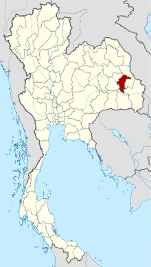
Peta Thailand dengan Provinsi Yasothon yang diarsir
Negara Thailand
Ibu kotaYasothon
Pemerintahan
 • GubernurPrasert Luechathanon[1]
Luas
 • Total4.162 km2 (1,607 sq mi)
Peringkat54
Populasi
 (2018)[3]
 • Total538.729
 • Kepadatan130/km2 (300/sq mi)
Zona waktuUTC+7 (Zona waktu Thailand)
Kode ISO 3166TH-36
Situs webwww.yasothon.go.th

Yasothon (bahasa Thai: ยโสธร) adalah salah satu provinsi (changwat) di timur laut Thailand. Provinsi-provinsi yang berbatasan (dari utara, searah putaran jarum jam) dengan provinsi ini, antara lain Maha Sarakham, Roi Et, Sisaket, Amnat Charoen, dan Ubon Ratchathani. Ibu kotanya adalah Yasothon.[4]

Pembagian administratif
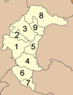
Peta Distrik
Peta Distrik

Provinsi ini dibagi menjadi 9 distrik (amphoe). Distrik-distrik ini dibagi-bagi lagi menjadi 78 subdistrik (tambon) dan 885 desa (muban).

  1. Mueang Yasothon
  2. Sai Mun
  3. Kut Chum
  4. Kham Khuean Kaeo
  5. Pa Tio
  1. Maha Chana Chai
  2. Kho Wang
  3. Loeng Nok Tha
  4. Thai Charoen


Referensi

  1. ^ "ประกาศสำนักนายกรัฐมนตรี เรื่อง แต่งตั้งข้าราชการพลเรือนสามัญ" [Announcement of the Prime Minister's Office regarding the appointment of civil servants] (PDF). Royal Thai Government Gazette. 136 (Special 242 Ngor). 19. 28 September 2019. Diarsipkan dari versi asli (PDF) tanggal 2019-09-29. Diakses tanggal 24 November 2019. 
  2. ^ Advancing Human Development through the ASEAN Community, Thailand Human Development Report 2014, table 0:Basic Data (PDF) (Laporan). United Nations Development Programme (UNDP) Thailand. hlm. 134–135. ISBN 978-974-680-368-7. Diakses tanggal 17 January 2016, Data has been supplied by Land Development Department, Ministry of Agriculture and Cooperatives, at Wayback Machine. [pranala nonaktif]
  3. ^ "รายงานสถิติจำนวนประชากรและบ้านประจำปี พ.ศ.2561" [Statistics, population and house statistics for the year 2018]. Registration Office Department of the Interior, Ministry of the Interior (dalam bahasa Thai). 31 December 2018. Diarsipkan dari versi asli tanggal 2019-06-14. Diakses tanggal 20 June 2019. 
  4. ^ "พระราชกฤษฎีกา เปลียนแปลงฐานะเทศบาลตำบลยโสธรเป็นเทศบาลเมืองยโสธร พ.ศ.๒๕๓๗" [Royal Decree Re: Change the status of Yasothon Subdistrict Municipality to Yasothon Town Municipality B.E.2537 (1994)] (PDF). Royal Thai Government Gazette. 111 (52 Kor): 46–47. 23 November 1994. Diarsipkan dari versi asli (PDF) tanggal 2012-06-09. Diakses tanggal 10 December 2019. 

Pranala luar

15°48′8″N 104°8′23″E / 15.80222°N 104.13972°E / 15.80222; 104.13972

Kembali kehalaman sebelumnya