Neudenau
| Wappa | Deitschlandkart | |
|---|---|---|

|
| |
| Basisdata | ||
| Bundesland: | Bade-Wirttebärg | |
| Regierongsbezirk: | Stuegert | |
| Landkroes: | Haalbrunn | |
| Heh: | 189 m i. NHN | |
| Fläch: | 32,9 km² | |
| Eiwohner: |
5643 (31. Dez. 2024)[1] | |
| Bevelkerongsdicht: | 171 Eiwohner je km² | |
| Boschtloetzahl: | 74861 | |
| Vorwahlen: | 06264, 06298 | |
| Kfz-Kennzoeche: | HN | |
| Gmoedsschlissel: | 08 1 25 068 | |
| LOCODE: | DE NDA | |
| Stadtgliderong: | Kernstadt, 4 Stadtdoel | |
| Adress vo dr Stadtverwaltong: |
Hauptstraße 27 74861 Neudenau | |
| Webpräsenz: | ||
| Schuldes: | Manfred Hebeiß (CDU) | |
| Lag vo de Stadt Neudenau em Landkroes Haalbrunn | ||
 | ||

Neudene (amtlich Neudenau ) ischt a Stadt em Landkroes Haalbrunn en Bade-Wirttebärg. D Stadt hot 5643 Eiwohner (Stand: 31. Dezember 2024).
Geografi
Neudene leit an dr Jagscht. D Nochbergmoede vo Neudene send Billigheim, Möckmühl, Hardthausen am Kocher, Neuenstadt am Kocher, Bad Friedrichshall ond Gundelsheim.
Vo dr Gmarkong send 55,5 % Landwirtschaftsfleche, 31 % Wald, 11,3 % Sidlongsfleche ond 2,2 % sonschtiche Fleche.[2]
Gmoedsglidrong
Zua Neudene gheret Stadtdoel Herbolzheim, Neudenau ond Siglingen.
Gschicht
Neudene ischt zom erschte Mol gnennt worda em Johr 1251 als Nidenowe.
Verwaltong
Neudene ghert zua koem Verwaltongsverband.
Dr Schuldes vo Neudene ischt dr Manfred Hebeiß.
Wahla
Ergäbnis vo de Landdagswahla seid 2006:[3]
| Johr | CDU | Greane | SPD | FDP | Lenke1 | AfD | Sonschtiche |
| 2016 | 30,6 % | 23,3 % | 14,6 % | 7,3 % | 1,8 % | 19,1 % | 3,3 % |
| 2011 | 46,7 % | 18,6 % | 21,1 % | 3,9 % | 2,1 % | 7,5 % | |
| 2006 | 54,3 % | 6,1 % | 20,7 % | 8,1 % | 2,8 % | 7,9 % |
1 2006: WASG, seid 2011: Die Linke
Dialekt
Dr Dialekt vo Neudene ghert zom Sidfränkisch.
-
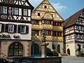 Rotsbronna mit Rothaus vo 1587
 -
 Rescht vo dr Stadtmauer
 -
 Jagschtbrick
 -
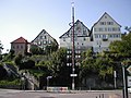
 Schloss Neudene
 -
 Alte Mihle an dr Jagscht
 -
 Pfarrkirche St. Laurentiu
 -
 Wolfgangskapell
 -
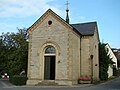 Heilich-Kreiz-Kapell


Weblink
Fuaßnota
- ↑ Statistisches Landesamt Baden-Württemberg – Tabellengruppe 12411: Fortschreibung des Bevölkerungsstandes zum 31. Dezember 2024 (Hilfe dazu).
- ↑ Statistisches Bundesamt: Bodenfläche nach Art der tatsächlichen Nutzung - Stichtag 31.12. - regionale Tiefe: Gemeinden, Samt-/Verbandsgemeinden (bis 2011)
- ↑ Statistisches Landesamt Baden-Württemberg: Landtagswahl (Memento vom 7. Juli 2019 im Internet Archive)
Content Disclaimer
Informasi ini disarikan dari Wikipedia dan disajikan kembali untuk tujuan edukasi. Konten tersedia di bawah lisensi CC BY-SA 3.0. Kami tidak bertanggung jawab atas ketidakakuratan data yang bersumber dari kontribusi publik tersebut.
- The information displayed on this website is sourced in part or in whole from Wikipedia and has been adapted for the purpose of restating it. We strive to provide accurate and relevant information, however:
- There is no guarantee of absolute accuracy. Wikipedia is an open, collaborative project that can be edited by anyone, so information is subject to change.
- It is not intended to constitute professional advice. The content displayed is for informational and educational purposes only. For important decisions (e.g., medical, legal, or financial), please consult a professional.
- Content copyright. Wikipedia is licensed under the Creative Commons Attribution-ShareAlike License (CC BY-SA). This means that content may be reused with appropriate attribution and shared under a similar license.
- Responsible use. Any risk arising from the use of information from this website is entirely the responsibility of the user.


